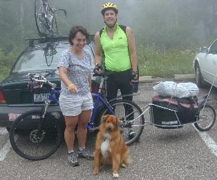
July 23, 2004: Drove up to the Widow's Kip B&B to start the adventure.
Suzanne was doing me a HUGE favor by driving me up there! Without her, I don't know
how I would have made it to the start of the road. We got to the B&B a bit late, but once
we were there we managed to get settled and relax a bit. I was a bit nervous, but being
nervous made me feel good about what I was doing. A real adventure should always
inspire a little bit of fear at the start.
July 24, 2004: Suzanne did a long ride/run in the morning, while I was
worked on Amy (my bike.) Then she drove me to milepost 21.0 on the Skyline Drive,
and I did the ride from there North to Front Royal. The last four miles were all downhill,
and I managed to make the entire trip in something like 90 minutes. I'm SO glad I didn't
have to do this stretch uphill. Going uphill instead of down would have been a hard way
to start the trip. 21.0 miles for the day, 21.0 miles total.
 July 25,
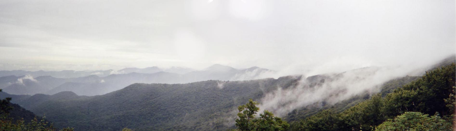
2004: Suzanne dropped me off at milepost 21.0 again, and I started my trip. It was
foggy the entire day, but I had tons of fun. I spent a lot of time stopping to adjust stuff on
the bike. I was mad at myself for not having my bike in better shape before the trip. My
front brake wasn't set up properly, and the cleats on my shoes were out of alignment.
Luckily, I wasn't in any hurry.
July 25,
2004: Suzanne dropped me off at milepost 21.0 again, and I started my trip. It was
foggy the entire day, but I had tons of fun. I spent a lot of time stopping to adjust stuff on
the bike. I was mad at myself for not having my bike in better shape before the trip. My
front brake wasn't set up properly, and the cleats on my shoes were out of alignment.
Luckily, I wasn't in any hurry.
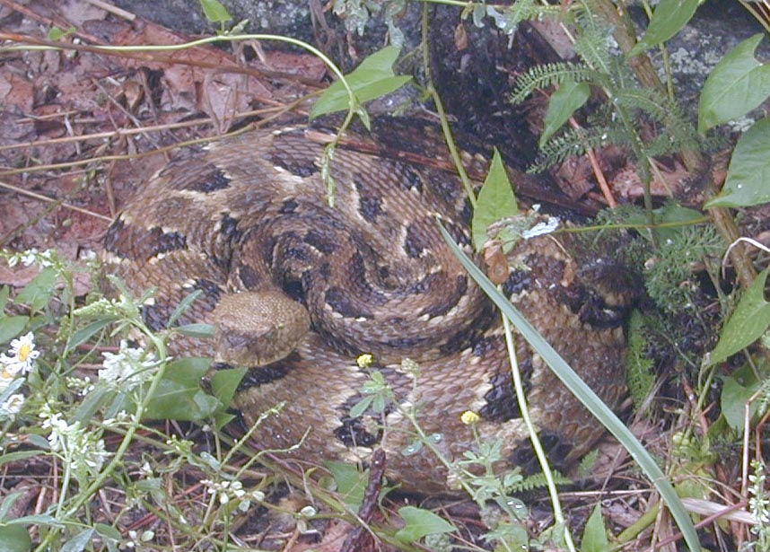
At 3:00PM I stopped to take a break at one of the overlooks. There was no view
because of the fog, but I still saw something rather interesting: A copperhead snake!
When I leaned Amy against a stone wall at the overlook, I noticed something funny
looking by the rear wheel. When I looked closer, I saw that it was a copperhead coiled
up and ready to strike. Yoikes! After a few tense seconds, I eased the bike away from
the snake and moved it 20 or 30 feet farther up the wall. Then I went for the camera and
got a few good shots. 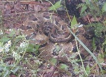 Somewhere around milepost 39, as I was bombing downhill in the fog, I had another fun
encounter with nature. I was going well over 40mph, when out of the fog I saw what
appeared at first to be a large dog. Then I realized that whatever I was seeing was WAY
too big to be a dog. It was, in fact, a BEAR. He didn't hear me coming until I was
almost on him, so I passed within 15 feet or so. He wasn't off the other side of the road
when I went passed him. After both a copperhead and a bear on my first real day of
travel, I knew I was in for a wonderful trip.
I spent the night at the Big Meadows campground. I had a good camping spot, but
everything got soaked because it was so foggy. 30.0 miles for the day, 51.0 miles total.
Somewhere around milepost 39, as I was bombing downhill in the fog, I had another fun
encounter with nature. I was going well over 40mph, when out of the fog I saw what
appeared at first to be a large dog. Then I realized that whatever I was seeing was WAY
too big to be a dog. It was, in fact, a BEAR. He didn't hear me coming until I was
almost on him, so I passed within 15 feet or so. He wasn't off the other side of the road
when I went passed him. After both a copperhead and a bear on my first real day of
travel, I knew I was in for a wonderful trip.
I spent the night at the Big Meadows campground. I had a good camping spot, but
everything got soaked because it was so foggy. 30.0 miles for the day, 51.0 miles total.
July 26, 2004: Another day of riding in the fog, but this was fine because it
kept me nice and cool. I stopped at Loft Mountain for lunch, where a nice 70 year old
woman talked my ear off for a hour. Her husband was hiking the AT this year, but he
was having some difficulty and going really slow. She was nice enough to let me borrow
her copy of the Thruhikers Companion so I could get hotel information for Waynesboro.
The book I was using as my guide wasn't very good about covering the facilities available
at each city. I decided to push on to Waynesboro and make it a long day. I needed to
visit the bike shop and post office in Waynesboro so I could mail some some gear, and
buy some stuff I forgot. The ride into Waynesboro was tougher than the guidebook
suggested it would be, but I got there soon enough. I rode all the way into town to get
dinner and visit the bikeshop. The problem with riding off the parkway is that you
always have a descent off the parkway, and a nasty climb back. 54.4 miles for the day,
105.4 total.
July 27, 2004: I got a late start out of Waynesboro because I rode all the
way into town (again) to go to the post office, then I had a late breakfast at Weasie's
Diner. By mile 27.0 on the BRP, I was ready to get off the bike. I did the STEEP
downhill to the Tye River Campground. When I got there, I noticed that the front brake
lever on my bike had almost fallen off! I can't imagine how much trouble I would have
been in if that level came off. I was somewhat stressed about the brake lever, because I
didn't know how I was going to fix it. A bolt had come undone, and was missing the nut
to hold it on. Where the heck was I supposed to get a nut the same size as the one that
fell off? I decided to use my time-tested problem solving method of "sit down and have a
snack, the answer will come to you." And what do you know... it worked! About half
way through a candy bar, I realized that my rear fender was held on with a screw/bolt of
approximately the same size as the one that fell off the brake lever. I took the bolt off the
fender, and lo and behold... it was a perfect match! The rear fender could be held
together with some dental floss and duct tape, leaving me with a perfect front brake an
almost perfect fender (which was an optional piece of gear anyway.) Coming up with
this fix left me in a really good mood. My mood was made even better when the owner
of the campground said he could drive me back up The Parkway in the morning. After
my experience in Waynesboro, I wasn't eager to repeat a steep two mile climb just to get
to the start of a day on The Parkway. After a nice dinner of Annies Shells and Cheese, I
took a long hot shower. Then I played some Ms. Packman (set a person record) and read
my guidebook a bit. I was up a bit later than I planned, but all in all it was a good day.
27.0 miles for the day, 132.4 total.
July 28, 2004: Was on The Parkway by 8:30AM, after a helpful lift from
the campground owner. As we were chatting on the drive up, I mentioned that I grew up
in Central PA. He said he wife from from a small town there called Lewistown.
Lewistown!!! That's where I was born! Small world. By 12:30PM I was at Otter Creek
Campground, where I decided to call it a day. My legs were a bit sore from the previous
days. I had a yummy lunch (salad and some buttered apples) at the campground
restaurant, and I got to see a few more copperheads. One of the copperheads was very
photogenic. I think I took seven or eight shots of him from different angles. I adjusted
the cleats on my shoes, which I think helped a lot. They were previously so far back on
the shoes that the cleat was bent, which made them really tough to get out of. By sliding
them forward, they were much easier to release. I think I needed to slide them forward
anyway, so I'm glad I took the ten simple minutes to do the work. 33.8 miles for the day,
166.2 miles total.
July 29, 2004: Left Otter Creek at 9:15AM. Had a really tough 3000' climb,
which took the entire morning. Crested the summit of the climb at 12:28PM. On the
way up I was passed by a guy on a Pinarello Opera bike (nice bike!). I saw him again
later, as I was coming down the other side of the mountain towards the Peaks of Otter
lodge. I stopped at the lodged for a much needed lunch at 1:00PM, then decided to push
on to Vinton, VA. Of course, when I arrived at Vinton I discovered that the only hotel in
town was full, so I had to ride all the way into Roanoke. City roads are the exact
opposite of The Parkway. Crowded, angry drivers, litter all over the road... not fun at all.
Stopped at a Hardees at 5:30PM to have a milkshake before moving on to the hotel. 51.4
miles on The Parkway, plus another 10 off the Parkway, 217.6 miles total.
July 30, 2004: Felt really down in the morning. I wasn't looking forward to
the ride back to The Parkway, and I was tired from the previous day. To top it off, the
weather forecast called for five days of rain. Somedays it isn't easy to get yourself
motivated :-(. I stopped a few times to eat before leaving town, and poked around all
day. After 23.8 miles, I decided to head into town at Adney Gap. Of course, my
guidebook sucked and there was absolutely nothing at Adney Gap. I ended up finding a
nice camping spot behind the local elementary school / library. There was a payphone at
a gas station / store, but I didn't have enough time on the card to make a call, and the gas
station didn't sell phone cards. Dammit. Bad day. Had a yummy dinner of Annies
Shells and Cheese, with tuna and some of my homemade cashew butter. I made a mental
note to a) get on the road earlier, and b) don't ride more than two miles off trail for
anything. 23.8 miles (plus more than 10 off The Parkway), 241.4 miles total.
July 31, 2004: Ate like a hog all day, and this really helped. I had energy to
spare. Got an early start, had three lunches, four or five snacks, and really felt solid all
day. Arrived at the Meadows of Dan at 4:00PM, and decided to stay at the campground
just off The Parkway. Took a nice long hot shower, then went to dinner (twice) and had a
nice relaxing day. The campground here has really awesome showers. 41.7 miles (+4),
283.1 miles total.
August 1, 2004: Stopped at the Mountain Top Restaurant for a long lunch.
Was trying to decide if I should push for Doughton Park, or stop at the American Youth
Hostel only 15 miles up the road. Decided I didn't have energy to push past the Hostel,
so I would simply cruise there and call it a day. This turned out to be a really good call,
as I got to meet some interesting folks at the hostel. Two fellas who were biking
Northbound were staying there. They had arrived the day before but were taking a day
off to recouperate. Both guys were graduate students at SUNY Bingamton, which is
where Suzanne's brother went to college. I had a fun time chatting with these guys. They
made me a nice dinner of pasta and sausage. They started in New Orleans, then got to
Alabama and decided to rent a car. Then they started again from Asheville and were
riding up to Waynesboro. The hostel had two really cool dogs, one names Oatmeal and
the other named Minnie. Oatmeal was really good at playing fetch, so I played with him
until my arm got sore. The hostel also had a fine selection of Bicycling magazines. It
was a really nice place to stay, and it was only a few hundred level yards off The
Parkway, so the return trip was easy. 36.8 miles for the day, 319.9 miles total.
August 2, 2004: On the parkway at 9:30AM. Forced myself to eat/drink a
lot, and once again this really helped my energy level. I was able to knock off my
morning climb with much more energy than normal. Half way up the first climb, a nice
lady offered me a soda. I declined, but I was happy to have the offer anyway. I stopped
at the coffee shop at Doughton Park for lunch, then decided to wait as a few storms
passed. While I was waiting, I ran into a guy I met during my 2001 Appalachian Trail
Thruhike! He and his girlfriend were just out riding their bikes for a few days, but I was
wearing an AT shirt, and when he saw it he asked if I had hiked the trail. It took a few
seconds to realize that he was indeed the guy I had met during my hike. He couldn't
remember my name, but as soon as I mentioned where we met, he remembered everyone
I was with, and where we went, etc.. One of the couples I hiked with was going to stay at
his house the very next weekend.
After my long siesta for lunch, I decided to push on to Glendale Springs. The profile
map in my guidebook was criminally innacurate for this section. When I got to Glendale
Springs, I went straight for the campground, then hit the Gathering Place for dinner.
While at the Gathering place, I met a guy named "Sheriff" who finished HIS Appalachian
Trail hike only three days after me. I knew from talking to another hiker that there was a
class-of-2001 thruhiker in Glendale Springs, but I didn't know where. Turns out he also
did a 6000 mile bicycle ride in 2002. I had a lot of fun talking to him, and when I was
done with the meal he was was kind enough to tell me that it was on him (his father owns
the restaurant.)
What an excellent day on the road. Met two folks who were on the Appalachian Trail at
the same time as me, got a free meal, and knocked out 44.5 miles, bringing the total up to
364.4 miles.
August 3, 2004: Yet another day where the profile map in my guidebook
was way off. I noticed that I have the 3rd edition of the book, but the stores along The
Parkway are all carrying the 4th edition. The profile maps in the 4th edition are much
better than those in the 3rd. I was tempted to buy the 4th edition, just so I wouldn't have
to spend so much of my day pissed off at the 3rd edition, but then I decided to just enjoy
the road and not worry so much about all the climbs. I ended up going to Blowing Rock,
but taking the wrong road into town. I finally found a hotel with a vacancy, and paid a
small fortune for a room. Oh well. 32.9 miles for the day, 397.3 miles total.
August 4, 2004: Got out early and felt pretty strong. Had a really solid
climb out of town, and considered pushing on to Little Switzerland. Stopped at noon at
Famous Louise's for lunch. I didn't realize until I got there that I had been to this place
once before. The first time I ever went Geocaching, a friend recommended this place. I
decided to make a good push to Little Switzerland because there weren't many options
short of there. When I got to Little Switzerland, I got a bad vibe from the place. I saw a
snack shop and figured that I would think about things over a smoothie. The smoothie
was overpriced and not very tasty, which made me think that if I stayed I would end up
paying another small fortune for another crappy hotel room. My guidebook said that
Crabtree Meadows campground was only five miles (uphill) farther, and I knew I was
going to have a really long day into Asheville the next day, so I decided to push on to the
campground. It was a tough ride, but I'm glad I got the miles out of the way. The
campground didn't have a phone, nor did it have a restaurant as described in my
guidebook, but the tent sites were great and the bathrooms were clean. I met two older
fellas named "Lucky Pierre" (hiked the AT in 1992) and Neil. They were both cycling
northbound and were only on their second or third day out. Both guys were from Rome,
GA, and they seemed to be fun guys. They had both been on many good adventures.
Neil spent three months in New Zealand a few years ago. 47.6 hard miles for the day,
444.9 miles total.
August 5, 2004: Got a fairly early start because I knew I was going to have
a tough 35 miles or so before the final descent into Asheville. The weather turned bad as
I did the climb passed Mt. Mitchell. Near the top of the climb, there were two sections
where I had to dismount and walk my bike because the winds were so bad. I was
swerving all over the road and was afraid I would have a bad bike vs. car incident. The
descent into Asheville was rather intense. The road surface was horrible, and both my
hands and feet were numb from being wet and cold. When I got to the US 70 intersection
at milepost 382.5, I went to a diner for lunch, but couldn't manage to warm up. I bailed
to a motel and took a long hot shower, then went to Arby's for dinner. I had to decide if I
was going to push from here to Cherokee (probably two hard days), or if I was going to
end the trip here and get back to Raleigh by Saturday. A local swimming pool has a
"doggie swim" on Saturday, where they let everyone bring their dogs. I really want to
see Holden and Gracie swim, and frankly, my legs/butt have had enough of this trip
already. Still, the weather is supposed to be really nice tomorrow, so maybe I could do
an out/back ride out of Asheville, then drive home saturday morning instead of
tomorrow. 43.0 miles for the day, 487.9 miles total.
August 6, 2004: Decided to get a rental car and head home. On the way to
the airport (which was 5.6 miles on the BRP and another 5 off the BRP) I stopped to have
a snack, and noticed in a local Arts & Entertainment magazine that there was an Ansel
Adams exhibit in Asheville. I missed the big Ansel Adams exhibit when it came through
Raleigh, but I caught a smaller one in Fayetville. I decided to go visit this exhibit on my
way out of town. After picking up my rental car and driving back to the hotel (where I
had stashed my trailer), I zipped into Asheville and saw the exhibit. It was a really well
done exhibit. I saw several prints I had never seen before. My favorite set of prints was
a series of prints over 50 years, all from the same negative. It was really neat to see how
Ansel's printing style changed over his career. When he started, his prints were very soft
and had a romantic feeling to them. By the end, he was using extremely high contrast,
and his pictures looked more dramatic. 5.6 miles for the day, 493.5 miles total.
My current plan is to go back to Asheville some time in the fall (Suzanne has said she
will join me) and do the section between Asheville and Cherokee. I think it will be fun to
do that section without hauling my trailer the entire way. I couldn't believe how much
harder the mountains are when hauling a trailer!
I couldn't have asked for a better adventure. The weather was (mostly) good for me, and
I was able to meet some interesting people and do some good training. I need at least one
good adventure like this every year. Now I have to figure out what I'm going to do next.
Maybe do coast-to-coast ride? Or a tour in Europe? Hrmmm... so many possibilities.
EPILOG:
I didn't get a chance to finish the ride in the fall of 2004, but I went
back in 2005 and finished the section between Asheville and Cherokee.
It took me
four
rather
tough
days because I did the entire section as a series of out-back rides.
It was a beautiful 80 mile stretch of road, so I didn't mind doing
the section in each direction.
 July 25,
2004: Suzanne dropped me off at milepost 21.0 again, and I started my trip. It was
foggy the entire day, but I had tons of fun. I spent a lot of time stopping to adjust stuff on
the bike. I was mad at myself for not having my bike in better shape before the trip. My
front brake wasn't set up properly, and the cleats on my shoes were out of alignment.
Luckily, I wasn't in any hurry.
July 25,
2004: Suzanne dropped me off at milepost 21.0 again, and I started my trip. It was
foggy the entire day, but I had tons of fun. I spent a lot of time stopping to adjust stuff on
the bike. I was mad at myself for not having my bike in better shape before the trip. My
front brake wasn't set up properly, and the cleats on my shoes were out of alignment.
Luckily, I wasn't in any hurry.